


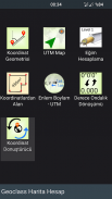

Geoclass Surveying Calculator
Perihal Geoclass Surveying Calculator
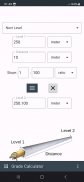
Kalkulator Ukur Geoclass mempunyai alat yang berkuasa untuk mengukur, menetapkan dan kejuruteraan awam.
Geoclass menyokong unit metrik dan imperial untuk jarak dan kawasan. Unit koordinat adalah dalam metrik dan darjah.
Menggunakan Geoclass anda boleh lakukan:
- Kumpul mata: Anda boleh mengumpul mata dan berkongsi mata dengan modul Peta UTM. Anda juga boleh menavigasi ke mata.
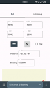
- Ukur jarak, bearing / azimut dari dua titik.
- Ukur sudut dari 3 mata.
- Kira latitud, longitud atau X,Y daripada koordinat, jarak dan bearing / azimut.
- Persimpangan; hadapan, garisan - garisan dan bulatan sebanyak 3 mata
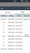
- Tukar longitud latitud kepada UTM atau sebaliknya
- Kira perpuluhan kepada darjah, minit, saat
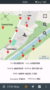
- Tinjau koordinat latitud dan longitud. Navigasi ke sana dari kedudukan anda dengan label jarak pada peta
- Navigasi untuk menyelaras dari kedudukan anda pada peta
- Paparkan lokasi UTM pada peta dalam talian dengan koordinat latitud, longitud, MGRS, X, Y
- Hasilkan koordinat daripada dua titik. Anda boleh menjana menggunakan X, Y atau latitud, longitud
- Tukar koordinat tempatan
- Kira kawasan daripada koordinat X,Y
Anda boleh mengikuti berita tentang aplikasi di Halaman Facebook:
fb.me/surveyingcalculator
Geoclass Surveying Calculator - Versi 3.6.0
(08-12-2024)Geoclass Surveying Calculator - Maklumat APK
Versi APK: 3.6.0Pakej: org.project.geoclassVersi Terkini Geoclass Surveying Calculator
Versi lain


Aplikasi dalam kategori sama

Anda juga mungkin suka...


